← Back to Blog·June 17, 2026·12 min readRiver Guides
Meramec River · St. Louis's home float

Meramec River
Float Trip Guide.

Live conditions, the best float sections by mile marker, the caves and springs worth stopping for, the full outfitter and campground directory, fishing regulations, and a built-in trip planner — your complete guide to floating the Meramec.

Meramec River hero
Length
~218 mi
Difficulty
Class I
Region
Ozarks
Season
Apr–Oct
Access
MDC & Parks
Headwaters
near Salem
Typical distance
5–20 mi day floats; overnight to 30+ mi
Best for beginners
Meramec State Park → Sand Ford (7 mi)
Primary gauge
Sullivan · USGS 07018500
Recommended outfitter
Meramec State Park canoe rental
Live conditions

Today on the Meramec

Eddy reads the gauge, the trend, and the forecast and writes a fresh take a few times a day. Use it as one input alongside your own judgment, the outfitter you’re renting from, and the most recent NPS advisories.

The pitch

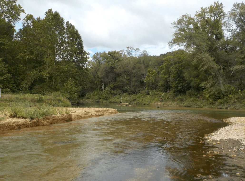
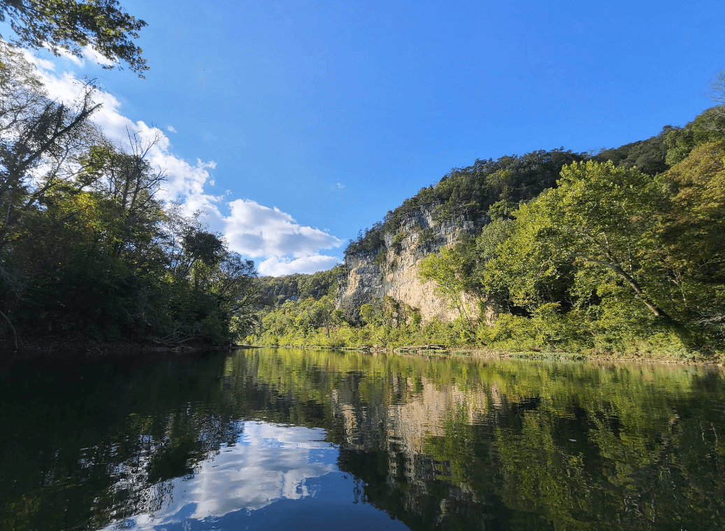
Why the Meramec is different

The Meramec is St. Louis's home float. One of the longest free-flowing rivers in Missouri, it runs about 90 minutes down I-44 to the outfitter towns of Steelville and Sullivan — the closest quality float water to the city. It's rain-fed, not spring-fed, which makes it one of the flashiest rivers in the Ozarks: gorgeous and lively when the water's up, and unlike the Current, never guaranteed to be floatable just because it's summer.

  • Closest quality float to St. Louis. About 90 minutes to Steelville or Sullivan on I-44. No other Ozark float this good is this close to the metro.
  • Caves everywhere. Onondaga Cave and Meramec Caverns are show caves right on the river, and Fisher Cave runs lantern tours from Meramec State Park. The bluffs are riddled with them.
  • Rain-fed and flashy. The Meramec can spike 5–10 feet in hours after a hard rain and drop fast in a dry spell. There's no spring base flow to fall back on — the gauge is everything.
  • Three rivers in one. A narrow, trout-tinged upper river; a bluff-and-cave middle that's the prettiest water; and a wide, gentle lower river built for tubes and big groups.
Float sections

Pick your float

The Meramec divides cleanly into character zones. Pick by how much time you have, who you’re paddling with, and what you want to see.

Segment · upper

Upper Meramec — Maramec Spring to Onondaga

The headwaters reach near St. James and Steelville: narrower, scenic, and trout-tinged. The Woodson K. Woods-to-Scotts Ford stretch is a Red Ribbon Trout Area. Needs more water than the lower river, and rewards it with solitude and bluffs.

Woodson K. Woods → Scotts Ford
1

Woodson K. Woods Scotts Ford

Open this float in the planner →

The Red Ribbon trout run

Distance
9 mi
Float time
4–5 hr
Class
I–II
Crowd
Quiet

The practical top of the float, just below Maramec Spring near St. James. From Woodson K. Woods (mile 26.2) to Scotts Ford (mile 35.1) is a Red Ribbon Trout Area — one of the few Meramec stretches holding rainbow and brown trout. Narrower and more scenic than downstream; it needs more water to float cleanly.

Best for: Anglers, paddlers chasing solitude
Segment · middle

Middle Meramec — Onondaga to Meramec State Park

The finest water on the river: about 20 miles of towering limestone bluffs, cave mouths, springs, and wide gravel bars. Most Steelville-area outfitters run this stretch, with 5- and 9-mile options.

Onondaga Cave SP → Meramec State Park
2

Onondaga Cave SP Meramec State Park

Open this float in the planner →

The bluff-and-cave middle

Distance
20 mi
Float time
Full day or overnight
Class
I–II
Crowd
Moderate

The finest water on the river — about 20 miles of towering limestone bluffs, cave mouths, springs, and wide gravel bars. Most Steelville outfitters run this stretch with 5- and 9-mile options. Pass Campbell Bridge (mile 73.6), Blue Springs Creek (mile 78.6), and Green's Cave before finishing at Meramec State Park (mile 88), the river's hub for camping and cabins.

Best for: Everyone — the best of the Meramec
Segment · lower

Lower Meramec — the park to the metro

Below Meramec State Park the river widens and gentles. The Meramec Caverns stretch draws big summer tube crowds; farther down toward Robertsville and Eureka it's a quieter, wider metro-edge paddle.

Meramec State Park → Sand Ford
3

Meramec State Park Sand Ford

Open this float in the planner →

The Meramec Caverns float

Distance
7 mi
Float time
2–4 hr
Class
I
Crowd
Busy summers

The busy summer stretch. From Meramec State Park (mile 88) the river widens and gentles past Spanish Claim and the Meramec Caverns area (mile ~94) down to Sand Ford (mile 95.4). Easy Class I water, big gravel bars, and the most crowded weekends on the river — go midweek if you can.

Best for: Families, tubes, big raft groups
Sand Ford → Red Horse
4

Sand Ford Red Horse

Open this float in the planner →

The quiet lower river

Distance
17 mi
Float time
Full day
Class
I
Crowd
Sleepy

Below Sand Ford the river broadens and the crowds thin. Past Chouteau Claim (mile 108.5) to Red Horse (mile 112) it's a wide, slow, metro-edge paddle — far quieter than the park stretch. River 'Round Conservation Area and Robertsville State Park carry the float on toward Pacific and Eureka.

Best for: Long quiet drifts, anglers
Off-river stops

Springs & sights worth stopping for

mile 28
Maramec Spring
Missouri's 5th-largest spring, in privately run Maramec Spring Park near St. James — a catch-and-keep trout park (Missouri trout tags required). Spelled 'Maramec' for the spring and park, 'Meramec' for the river.
mile 68
Onondaga Cave
A National Natural Landmark show cave at Onondaga Cave State Park, right at the river access. Guided walking tours run April–October, about an hour underground.
mile ~85
Green's Cave
A large wild cave in a river bluff above Meramec State Park — a well-known canoe landmark. Admire it from the water; entry is restricted.
mile 88
Fisher Cave
A wild cave at Meramec State Park with ranger-led lantern tours — one of the more decorated caves in the eastern Ozarks.
Directory

Outfitters, campgrounds & lodging

Every active service that operates on the Meramec. Tap a phone number to call; tap Reserve to book.

Outfitters
11
Huzzah Valley Resort
Steelville, MO
Open April through October. Restaurant and pool seasonal.
Bird's Nest Lodge / Meramec River Resort
Steelville, MO
Seasonal — typically April through October.
Adventure Outdoors
Steelville, MO
Seasonal — typically April through October. Call ahead to confirm — outfitter building suffered flood damage in late 2024.
Green's Canoe Rental & Campground
Steelville, MO
Seasonal — verify current schedule.
Garrison's River Resort
Steelville, MO
Open year-round. Floating seasonal April through October.
Meramec Park Concessions
Sullivan, MO
Caveman Floating at Meramec Caverns
Stanton, MO
Campgrounds
5
Onondaga Cave State Park
Leasburg, MO
Park open year-round. Cave tours seasonal (spring-fall). Campground open April through October.
Arapaho Campground
Steelville, MO
Seasonal — typically April through October.
Meramec Caverns Campground
Stanton, MO
Campground open April 1 – October 31. Cave tours year-round.
Cabins & lodges
5
4J Vacation Rentals
Steelville, MO
Kick'n K Farmhouse
Steelville, MO
Driftwood Vacation Rentals
Steelville, MO
USGS data

Water levels & gauge

Check the gauge before you load the truck. The trend over the last week matters more than today’s number — a falling river after a flood is fine; a rising river isn’t.

Park rules

Regulations

Red Ribbon trout area
Woodson K. Woods to Scotts Ford is a Red Ribbon Trout Area with special catch-and-release-style limits. Porous-soled (felt) waders are prohibited to prevent spreading invasive species.
Read the official rule →
Black bass & goggle-eye limits
Special MDC length and daily limits apply to smallmouth bass and goggle-eye on parts of the Meramec. Check current regulations before you keep any fish.
Read the official rule →
Camping
Meramec State Park has developed campgrounds and cabins on the river. Gravel-bar camping is allowed on public land, but some stretches near state parks have restrictions — register at the park office for backcountry sites.
Read the official rule →
Glass & trash
Pack out everything you bring in. Glass is discouraged on Missouri streams — it's a heavily used river close to the city, so leave the gravel bars clean.
Read the official rule →
By the season

When to go

Mar–Apr
Spring water, cool.
Higher flows and fewer people. Bring a layer; the water's cold.
May–Jun
Sweet spot.
Warm air, good water, bluffs greening up.
Jul–Aug
Peak crowds near the park.
The lower river is busy on weekends. Go midweek or float the upper for solitude.
Sep–Oct
Color and quiet.
Pleasant temps and thinner crowds; can run low in dry years — check the gauge.
Nov–Feb
Floatable in wet spells.
Cold and variable. It's rain-fed, so watch the forecast and the trend.
Getting there

Drive times

St. Louis
~1.5 hr to Steelville
Get directions →
Kansas City
~3.5 hr to Steelville
Get directions →
Springfield
~2.5 hr to Steelville
Get directions →
Columbia
~2 hr to Steelville
Get directions →
Pack & plan

Before you launch & on the water

Pack
  • PFDs (legally required — one per person, worn by anyone under 7).
  • Dry bag for keys, phone, ID, and a layer. Riffles flip beginners.
  • Drinking water (a gallon per person per day in summer) — there's no potable water on the river.
  • Reef-safe sunscreen and a hat — the lower river has long, shadeless stretches.
  • Hard-soled water shoes, not flip-flops. Gravel bars are rocky.
  • A cooler tied securely into the boat.
  • Trash bag — the Meramec sees heavy use; pack out everything.
Plan
  • It's rain-fed — check the gauge that morning. One of the flashiest rivers in the Ozarks. It can spike 5–10 ft after a storm and drop fast in a dry spell. There's no spring base flow like the Current's.
  • Match the gauge to your section. Steelville (USGS 07013000) and Cook Station read the upper river, Sullivan (07018500) the middle, Eureka (07019000) the lower. Conditions differ a lot over 100+ miles.
  • Upper for scenery, lower for tubes. Onondaga to Meramec State Park is the prettiest water; below the park is wider and better for big raft and tube groups.
  • Book Steelville weekends ahead. The state park and Meramec Caverns stretches fill up. Reserve outfitter shuttles in advance for summer Saturdays.
In the area

Nearby attractions

State Park
One of Missouri's most spectacular show caves, right at a river access. Walking tours run April–October.
State Park
The river's hub: campgrounds, rental cabins, Fisher Cave lantern tours, and trails. Camping reservations via Missouri State Parks.
Show cave
Commercial cave near Stanton with guided tours and riverfront camping — also runs a float outfitter with free shuttle for renters.
Trout park
Privately run trout park at the river's spring source near St. James — catch-and-keep trout (Missouri trout tags required) and a day-use fee.
Quick answers

FAQ

Most outfitter trips cover 5–9 miles and take 2–5 hours. The full Onondaga-to-Meramec State Park run (about 20 miles) is a 7–9 hour day or a comfortable overnight.
See also
Huzzah Creek — a clear Meramec tributary, great for day floatsCourtois Creek — Huzzah's quieter sister, same Steelville hubCurrent — the spring-fed crown jewel, about 3 hr south
Ready to launch?

Plan your Meramec River trip on Eddy

Open the Meramec River planner →
Safety first: Eddy is a planning guide only. Always consult local outfitters and authorities for current conditions before floating. Water levels can change rapidly. Wear life jackets and never float alone.